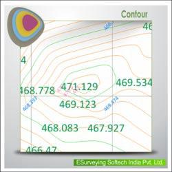

ESurvey Contours
Generates smooth contours quickly from point data available in CAD drawings Levels available in Excel or CSV files. It Includes
Key Features:
Import data from CSV, Excel or CAD for Contour generation
Generate Contours directly within CAD
Draw Section for any alignment fixed on the Contour Map
Generate Contour Area and Contour Volume instantly
Generate Boundary Based Contours
Generate Contours for Specific Levels
Generate Grid Elevations or Block Levels
Annotate Contours:
At Endpoints
At Mid-points
At Selected Points
At Specified Intervals
Draw Grid Elevations from existing Contours
Detailed Layerisation before exporting to CAD
Benefits:
No necessity of creating terrain for Contour generation
Quick and smooth contours
Lightweight contours thereby reducing the drawing file size
Generate Boundary, Grid Elevation, Grid annotation, Contours, Contour annotation in Single step.
Use ESurvey CAD irrespective of your CAD Package as ESurvey CAD works with AutoCAD® / ZW CAD / BricsCAD / Ares / ProgeCAD/GstarCAD
Cad cam consultant providing cad cam designing services which includes e survey cad services, earth work services, generating topological maps, calculating earthwork quantities and e topo drawing services.
More details:View company website
Its Free
Verify Now